The Major Mountains Of Malaysia
The southeast Asian nation of Malaysia is divided into two separate regions. There are a lot of things you want to know before traveling to Malaysia. Peninsular Malaysia is to the west, and East Malaysia's island regions are to the east. Numerous mountain ranges in both regions of the nation include some of the highest mountains in the nation. Peninsular Malaysia is bordered by mountain ranges on all sides, with Titiwangsa Mountain serving as the border between the north and south of the peninsula. The highest mountain ranges in East Malaysia, which form the border between Indonesia and Malaysia, run northeast to southwest. The Crocker Range, which divides the state of Sabah in half, is the tallest mountain range in Malaysia. After visiting or sighting these mountains, you can try the top foods in Malaysia for a full-blown experience. Below is a list of some of Malaysia's highest mountains.
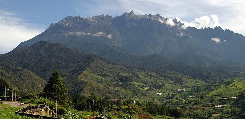
1. Mount Kinabalu
The tallest mountain in Malaysia and Borneo is called Mount. It is the 20th most prominent mountain in the world by topographic prominence and has an elevation of 13,435 feet, making it the third highest peak on an island on the planet. The mountain is situated in Sabah, Malaysia's Ranau District West Coast Division. As a World Heritage Site, Kinabalu Park preserves it. A new survey conducted in 1997 using satellite technology determined the summit height to be 4,095 meters above sea level, which is about 6 meters lower than the previously estimated and previously reported figure of 4,101 meters.
With between 5,000 and 6,000 different plant species, 326 different bird species, and more than 100 different mammalian species recorded, the mountain and its surroundings are among the most significant biological sites in the world. This diverse array of wildlife includes well-known species like the enormous Rafflesia plants and orangutans. UNESCO has designated Mount Kinabalu as a World Heritage Site. A climber in good physical condition can ascend Low's Peak, and there is no requirement for mountaineering gear along the main route. However, due to national park regulations, climbers must always be accompanied by certified guides and risk experiencing altitude sickness.
2. Mount Trusmadi
The second-highest mountain in Malaysia is Mount Trusmadi, which rises 8,668 feet above sea level. It is situated in the state of Sabah, about 40 kilometers north of Mount Kinabalu. Four districts are bordered by Mount Trusmadi's 184,000 hectares of forest. The mountain has five distinct vegetation types and a wide variety of plant and animal species. For the surrounding communities, Mount Trusmadi was a well-known hunting location. However, the mountain is currently a Class 1 Forest Reserve protected area. Mountain climbers will find the terrain difficult, but nature lovers will find the perfect natural beauty there.
3. Mount Tambuyukon
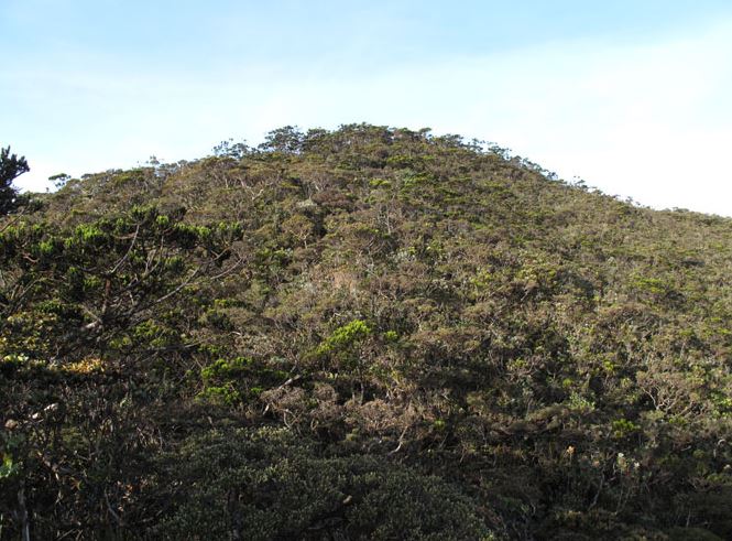
Twelve kilometers to the north of Mount Kinabalu is Mount Tambuyukon. At 8,462 feet above sea level, it is regarded as the third-highest peak in Malaysia and the highest mountain in South East Asia. Its peak is a sheer granite majesty and grandeur that appears to be shrouded in cloud. On the edge of Kinabalu Park is the twin peak of Mount Tambuyukon, which from a distance resembles a double-humped buffalo. In the Dusun language, the mountain's name translates to "Cheating Mountain." The mountain received its name because a guide by the name of Tam kept deceiving climbers into thinking the summit was not far away when in fact it was still a long way off. Numerous plant and animal species can be found on Mount Tambuyukon, which is known for its incredible biodiversity. The Series Substation and the Monggis Substation are two of the mountain's climbing routes.
4. Mount Murud
The sandstone mountain known as Mount Murud or Muru rises to a height of 2,424 meters in Limbang Division, Sarawak, Malaysia. The highest mountain in Sarawak, Mount Murud, is situated in the Kelabit Highlands at a distance between Miri and Limbang Division. Its elevation is 2,424 meters. It is a 4 km long, ENE-WSW-oriented white-yellowish sandstone mountain that was formed during the Miocene Epoch. The two highest points on Mount Murud are separated by only 15 meters.
Because specimens collected below this level can originate from the mountain surroundings, the UNIMAS expedition team defined the animal and plant species collected in the 1,500 to 1,800 m range above sea level as species originating from Mount Murud. Nine bird species that were previously thought to have originated from Mount Kinabalu are also present at Mount Murud, according to Mjöberg's 1925 observation. Another piece of evidence that supports this is the fact that both mountains have a high prevalence of pteridophytes (77%), and orchids (75%). Mount Murud and Mount Mulu are close to each other, but they have different summit flora. As of 1995, the summit flora of Mount Murud included a total of 35 pteridophytes, 7 gymnosperms, 96 monocotyledons, and 207 dicotyledons. Nepenthes murudensis, a tropical pitcher plant species, is named after the mountain and is believed to be endemic to its summit region. The only known location for Murad's black slender toad, Ansonia vidua, is this mountain.
5. Mount Mulu
Sandstone and shales make up Mount Mulu. It is the second-highest mountain in the state of Sarawak, behind Mount Murud, at 2376 meters. It is situated inside the boundaries of the park with the same name, Gunung Mulu. tried to conquer Mount Mulu in the 19th century. However, their efforts fell short. The southwest-southwest ridge that eventually led to the mountain's summit wasn't discovered until the 1920s, thanks to a Berawan rhino hunter by the name of Tama Nilong. Lord Shackleton and an Oxford University Expedition were led by Tama Nilong to the summit of Mount Mulu in 1932.
Mount Mulu has only one trek that leads to its summit, which is 24 kilometers from the park's administrative center. The journey to Camp 3 begins at the park's administrative center. The distance is 12 kilometers, and the elevation gain is 1,200 meters. Camp 3 is where the mossy forest begins. It will take some time to climb to Camp 4. Following Camp 4, there are a few vertical ascents requiring knotted ropes that ultimately lead to the summit. The first camp is situated on the route that leads down from Mount Mulu's summit. From Camp 1, it takes another 3-hour hike to get to the park headquarters.